A rare May blizzard has prompted a winter storm warning for the Sierra Nevada, threatening major highway closures and travel chaos. The storm is expected to impact the region starting on May 3, 2026, with significant snowfall predicted.
In the Sierra Nevada, snowfall totals are projected to reach between 1 to 2 feet at elevations above 6,000 feet, with up to 4 feet expected at the highest peaks. Additionally, wind gusts could reach between 50 to 70 mph, and possibly up to 80 mph in exposed areas. These conditions make Interstate 80 over Donner Pass particularly vulnerable to closures.
Meanwhile, a winter storm watch has been issued for specific mountain regions of Wyoming. Heavy snow is anticipated there as well, with forecasts suggesting between 4 to 10 inches at lower elevations and up to 16 inches above 9,000 feet. This watch reflects the unpredictable nature of weather patterns in mountainous regions.
Travel advisories have been released across affected areas, urging residents and visitors to postpone non-essential travel until at least Tuesday. Officials recommend that those who must travel prepare by stocking up on emergency supplies.
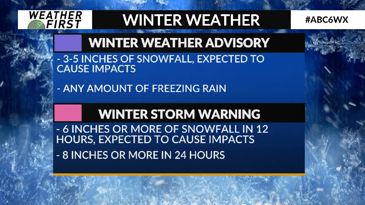
As this powerful late-season system moves eastward into Nevada, Colorado, and New Mexico after impacting California, authorities continue to monitor conditions closely. The National Weather Service has defined a winter storm watch as indicating a 50% chance of hazardous winter weather events occurring.
In light of these developments, officials emphasize the importance of preparedness. Individuals are encouraged to check their vehicles for necessary emergency items before embarking on any journey during this severe weather event.
The implications of this late-season blizzard extend beyond immediate travel concerns; it serves as a reminder of the variability of spring weather in mountainous areas. As conditions evolve, updates will be provided by local weather services.